The Boone Fork Trail is a 5 mile loop that is part of the Julian Price Memorial Park. The trail starts at the Picnic Area for the Julian Price Memorial Park between Mile Markers 296 & 297 on the Blue Ridge Parkway.
NOTE: You might need to bring waterproof boots. In the dry season, they should not be needed, but there were many places where keeping your feet dry would be a real challenge if it had rained.
Starting from the Picnic Area, go across the bridge, which is beside one of the bathroom facilities on the left as you enter the Picnic Area. Here you will be in a very nice open field and the start of the trail will be just to your right. There is a sign there showing the trail systems that are part of the Julian Price Memorial Park. If you don’t have a map, you may want to take a photo of the sign for reference later. NOTE: in some places, it states the trail is 4.9 miles and other places it has 5.0 miles. The trail is very well marked with Orange Diamonds.
A Kids Track Trail and the trail to Hebron Falls both start here. They use only a portion of the Boone Fork Loop Trail.
The first point of interest on this trail is an old lake bed. There is a marker there with details. The first .7 mile of this trail is the Kids Track Trail. It is very easy walking and flat. There are brochures for the children to take with them as they hike. The brochures encourage the children to look for different things, to make the hike more interesting to them.
After that the trail becomes more challenging, there are many roots and rocks to travel over. There is also the occasional low limb and a couple of rock outcropping’s. Be warned, watch where you are stepping and also watch your head. The day I hiked this trail, there was a heavy dew so the rocks were wet. Wet rocks can be very slippery.
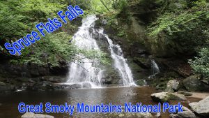
My favorite parts of this trail are all the waterfalls and rapids. There are several different ones, but the largest is Hebron Falls. Just before the 1.5-mile marker is a right turn to Hebron Falls. There is a directional sign marking the turn.
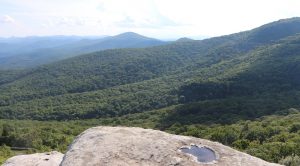
After about 3 miles of hiking along the water, you start going up, you are near the top of a mountain. There is a side trail that is not part of the Boone Fork Trail at mile 3.5. I suggest you take the short hike to the top of the mountain, for a very nice view of the area. I think the view is worth the effort.
Just past the 3-mile marker, you come to an intersection of several trails. The Boone Fork Trail will continue straight. The Mountain-To-Sea Trail and the Tanawha Trail will go right. There also is a sign with mileages to other points of interest.
Past the 4-mile marker, you enter the Julian Price Memorial Park Camp Ground. The trail will wind through the campground and go past the Ranger Station at the entrance to the Camp Ground. This will be at mile marker 4.5.
Another ½ mile through lush Rhododendrons will bring you to the open field you started from. A short walk across the field then across the bridge and you will be back at the parking lot.
This is one of the best hikes I have taken. It is 5 miles and moderate to strenuous. would put it Only the distance would classify it as strenuous. The trail is very well marked with usually lots of hikers. Boone fork Trail trail offers a lot of interesting things to see. It’s not just a walk in the woods!